

Hello River Lovers,
Do you know what a watershed is? What about the name of the watershed you live in? Or what a Watershed Management Authority does? Well keep reading and you’ll be able to answer all of these questions and more.
Everyone lives in a watershed! A watershed is an area of land that channels rainfall or snowmelt to the nearest creek, river, or stream.
The size of a watershed (also known as a drainage basin) is based on an area’s geography and topography. Its boundaries always follow the highest ridgeline around stream channels and connects at the lowest point on land where water then flows into another watershed. Watersheds are nested within each other and assigned specific Hydrologic Unit Codes (HUC). The smaller the HUC number the larger the area it represents (see list below). For more detailed information on HUC delineation visit this USGS website.
- HUC-2 Region: The United States has 21 major geographic areas or regions.
- HUC-4 Subregion: Each Region has from 3 to 30 Subregions with a total of 221.
- HUC-6 Basin: 378 total in the United States.
- HUC-8 Subbasin: The smallest is 700 mi². 2,264 total in the United States.
- HUC-10 Watershed: Size ranges from 62 to 390 mi².
- HUC-12 Subwatershed: Size ranges from 15 to 62 mi².
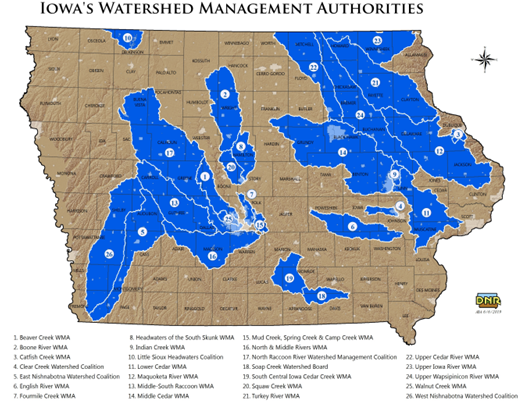
In 2010 Iowa lawmakers passed legislation authorizing the creation of Watershed Management Authorities (WMA). This was enacted to have a more localized approach to address specific needs with a HUC-8 watershed. A WMA is formed by two or more parties including cities, counties, Soil and Water Conservation Districts, and other stakeholders. The map below shows that Iowa currently has 26 WMA.
There are so many people in Iowa working to restore and protect our watersheds and waterways, including the Iowa Department of Natural Resources and the Iowa Watershed Approach. I challenge you to explore current and past projects and identify ways you can get involved or make a difference for your watershed.
Until next month, stay well!
Sara Carmichael, Executive Director
Featured Watershed
West Nishnabotna River Watershed

This watershed located in Southwest Iowa is a tributary of the Missouri River. Its drainage basin includes 489,500 acres of steeply rolling uplands and wide valleys. This area of the state is highly susceptible to erosion and stream degradation due to the heavy Loess type soil. Loess is a predominantly silt-sized sediment formed by the accumulation of wind-blown dust.
Find your HUC
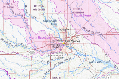
There are many great ways to figure out what watershed you live in. This website allows for you to explore all areas of the United States, yours included. Downtown Des Moines is in the HUC-2: Upper Mississippi Region, HUC-4: Des Moines, HUC-6: Des Moines, HUC-8: Middle Des Moines, HUC-10: Saylor Creek, Des Moines River, HUC-12: Saylor Creek, Des Moines River